Idaho Hunt Planner We got game.
Hunt Area
That portion of Unit 76 within the following boundary: Beginning at Soda Springs go north on State Highway 34 to Wayan, then south on the Wayan Loop Road, then south along the Lanes Creek-Diamond Creek Road to Timber Creek Road, then northeast along Timber Creek-Smoky Canyon-Stump Creek Road to the Idaho-Wyoming state line, then south along the state line to the Crow Creek Road, then southwest along Crow Creek-Wells Canyon-Georgetown Canyon Road to U.S. Highway 30, then north along U.S. Highway 30 to Soda Springs, the point of beginning.
More information about the Game Management Unit(s) in this area: 76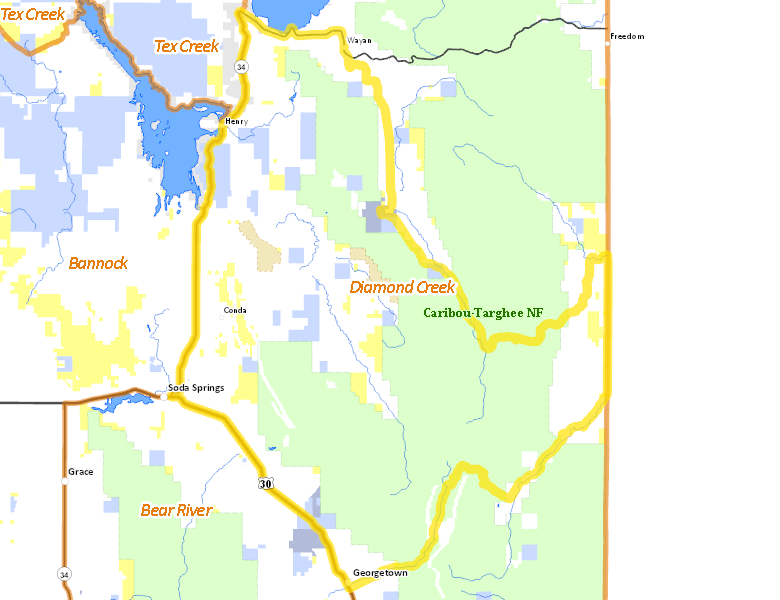
Surface Management
For government land, these data show the managing agency of the land, which may or not be the same as the owning agency.
 U.S. Forest Service (USFS) 47.8%
|
|
Private 42.01%
|
|
State of Idaho 5.52%
|
|
U.S. Bureau of Land Management (BLM) 3.86%
|
|
State of Idaho 0.61%
|
|
Indian Reservation / Bureau of Indian Affairs 0.2%
|
Make your own map of Hunt Area
Ownership data source: Inside Idaho
Access Yes! Properties
Access Yes! is Fish and Game program designed to improve hunting and fishing access to private land or through private land to public land by compensating willing landowners who provide access.
Forest Service Land
Check for road and area closures on National Forest websites
Federally-designated Wilderness Areas
No motorized vehicles are allowed in these areas.
There are no wilderness areas in .
Land Use/Land Cover
|
Forest
52.18
%
|
|
Rangeland
23.6
%
|
|
Dryland Agriculture
20.58
%
|
|
Irrigated-Sprinkler
1.93
%
|
|
Urban
1.13
%
|
|
Riparian
0.48
%
|
|
Irrigated-Gravity Flow
0.09
%
|
Make your own map of Hunt Area
Land Use data source: IDWR
Towns in this Hunt Area
- Wayan, Idaho 34