Idaho Hunt Planner We got game.
Hunt Area
Private land within the following boundaries: All of Unit 49; that portion of Unit 52A within Blaine County within the Little Wood, Fish Creek, and Huff Creek drainages; that portion of Unit 48 south of the Warm Springs drainage and within the Big Wood River drainage; and that portion of Unit 50 within the Copper Creek drainage.
More information about the Game Management Unit(s) in this area: 48 49 52A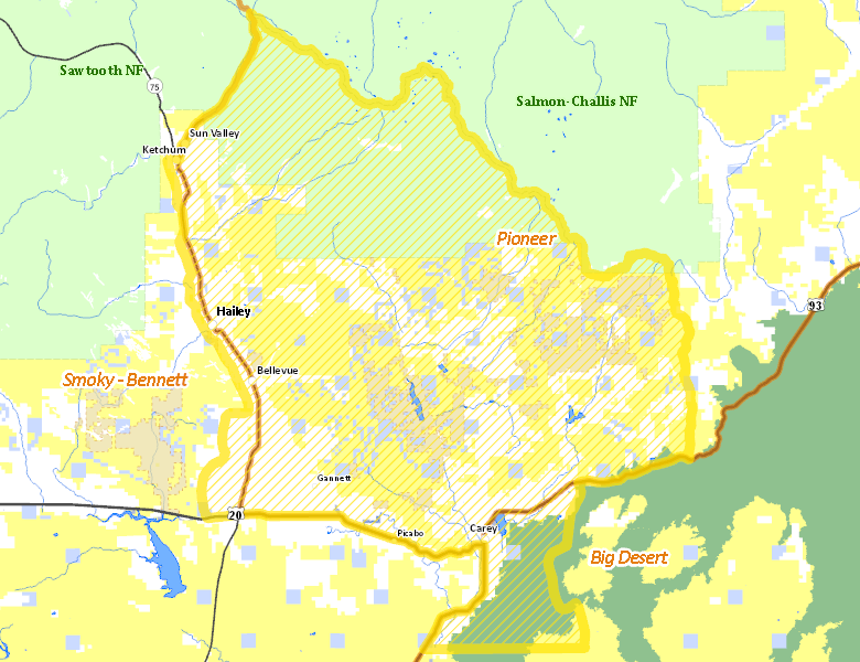
Surface Management
For government land, these data show the managing agency of the land, which may or not be the same as the owning agency.
 Private 36%
|
|
U.S. Bureau of Land Management (BLM) 28.34%
|
|
U.S. Forest Service (USFS) 24.41%
|
|
State of Idaho 6.23%
|
|
U.S. National Park Service (NPS) 4.87%
|
|
State of Idaho 0.14%
|
|
U.S. Bureau of Reclamation (BOR) 0.01%
|
Make your own map of Hunt Area
Ownership data source: Inside Idaho
Access Yes! Properties
Access Yes! is Fish and Game program designed to improve hunting and fishing access to private land or through private land to public land by compensating willing landowners who provide access.
- Little Fish Creek Grazing Assoc.
- Telfer Inc.
- Wood River Land Trust - Cowcatcher Ridge
- Wood River Land Trust - Porcupine Creek Preserve
- Wood River Land Trust - Draper Wood River Preserve
- Colorado Gulch Preserve
Forest Service Land
Check for road and area closures on National Forest websites
Federally-designated Wilderness Areas
No motorized vehicles are allowed in these areas.
There are no wilderness areas in .
Land Use/Land Cover
No landcover for this area is available at this time.
Towns in this Hunt Area
- Hailey, Idaho 75
- Sun Valley / Ketchum, Idaho 75
- Bellevue, Idaho 75
- Picabo, US 20